Angkor Wat: The Megacity Hidden Beneath the Jungle
Angkor Wat is the largest religious monument ever built, but the city around it was even more astonishing. LiDAR scans reveal a sprawling metropolis that collapsed under climate change.
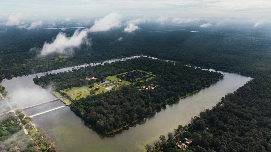
Most people think of Angkor Wat as a temple. It is, but that's like calling Manhattan a building. Angkor Wat was the ceremonial heart of a sprawling urban landscape that, at its peak in the 12th and 13th centuries, was the largest city on Earth. The greater Angkor region covered roughly 1,000 square kilometers, home to an estimated 750,000 to one million people at a time when London had maybe 50,000. Its hydraulic engineering network of canals, reservoirs, and waterways was the most sophisticated water management system the pre-industrial world had ever seen.
Then it collapsed. By the 15th century, the Khmer Empire had abandoned Angkor, and the jungle swallowed the city so completely that its true scale wasn't understood until airborne laser scans in the 2010s revealed an entire hidden metropolis beneath the forest canopy. What killed the greatest city of the medieval world? The answer involves drought, floods, and the terrifying fragility of systems that seem invincible.
What You'll Learn
- •Who Built Angkor Wat?
- •How Big Was the City of Angkor?
- •The Hydraulic City: Engineering That Fed an Empire
- •What LiDAR Revealed Beneath the Jungle
- •Why Did Angkor Collapse?
- •The Climate Connection: Drought, Floods, and Failure
- •Unsolved Mysteries of Angkor
- •Frequently Asked Questions
Who Built Angkor Wat?
Angkor Wat was built by King Suryavarman II, who ruled the Khmer Empire from approximately 1113 to 1150 CE. Unlike most Angkorian temples, which were dedicated to the Hindu god Shiva, Suryavarman II dedicated Angkor Wat to Vishnu, and the temple is oriented to the west (the direction associated with Vishnu) rather than the east.
Construction likely began around 1116 CE and took approximately 30 years. The labor force has been estimated at 300,000 workers, including 6,000 elephants for hauling stone. The temple was built from roughly 5 to 10 million sandstone blocks, some weighing up to 1.5 tons, quarried from Phnom Kulen, a plateau about 50 kilometers to the northeast, and transported to the site via a network of canals.
But Angkor Wat was just one piece, the most spectacular piece, of a much larger urban landscape. The broader Angkor region had been the center of the Khmer Empire since the 9th century, with successive rulers building their own temple complexes. Angkor Thom, the walled city surrounding the Bayon temple, was built by Jayavarman VII in the late 12th century. Each king built on the achievements of his predecessors, creating an accumulating urban sprawl that grew for over 600 years.

How Big Was the City of Angkor?
This is where Angkor's story shifts from impressive to genuinely staggering. For most of the 20th century, scholars studied Angkor as a collection of temples scattered through the jungle. They assumed the temples were religious sites surrounded by forest, with the population concentrated in small settlements nearby.
They were wrong. Dramatically wrong.
Research by the Greater Angkor Project, led by archaeologists Roland Fletcher at the University of Sydney and Christophe Pottier of the French School of Asian Studies (EFEO), combined ground surveys, aerial photography, and satellite imagery to reveal that the greater Angkor region covered approximately 1,000 square kilometers (roughly 400 square miles). That's larger than modern-day New York City's five boroughs combined.
The population estimates followed. Based on residential mound density, agricultural capacity, and water system throughput, researchers estimated that Angkor supported between 750,000 and one million people at its 12th-century peak. This made it, by a significant margin, the largest urban settlement in the world during the medieval period.
The city wasn't dense like a modern metropolis. It was a "low-density urban complex," a dispersed network of residential areas, temples, rice paddies, orchards, and water features connected by roads and canals. Think of it as a vast, planned landscape where the boundaries between city and countryside were blurred. This pattern of low-density urbanism was unique to Angkor and wasn't fully recognized until the 21st century.
The Hydraulic City: Engineering That Fed an Empire
French archaeologist Bernard-Philippe Groslier recognized Angkor as a "Hydraulic City" in the 1950s, understanding that water management was the foundation of Khmer power. But the true complexity of the system wasn't understood until Khmer researchers and international teams mapped it in detail after 2004.
The system had several components:
Barays (reservoirs). These enormous rectangular reservoirs stored monsoon rainwater for use during the dry season. The West Baray, still partially filled today, measures 8 kilometers by 2.1 kilometers and could hold approximately 56 million cubic meters of water. The East Baray was even larger. These weren't just storage tanks; they regulated water flow across the entire urban landscape.
Canals and channels. A network of canals distributed water from the barays and natural rivers to rice paddies, residential areas, and temple moats. The system was gravity-fed, using the gentle slope from the Kulen Plateau to Tonle Sap lake to move water across the landscape without pumps.
Rice agriculture. The hydraulic system enabled multiple rice harvests per year, supporting a population density far beyond what rain-fed agriculture alone could sustain. This surplus was the economic engine of the Khmer Empire, funding temple construction, military campaigns, and trade networks.
Temple moats. The moats surrounding temples like Angkor Wat weren't purely decorative. They served as local water storage, helped stabilize the soil beneath temple foundations, and connected to the broader canal network. Angkor Wat's moat alone is 190 meters wide and covers roughly 1.5 million square meters.
The sophistication of this system can't be overstated. The Khmer engineers managed water flows across hundreds of square kilometers with precision that allowed them to sustain the world's largest city in a monsoon climate where the difference between too much water and too little could be catastrophic. And eventually, it was.

What LiDAR Revealed Beneath the Jungle
In 2012, archaeologist Damian Evans of the University of Sydney led a team that used airborne LiDAR (Light Detection and Ranging) to scan 370 square kilometers around Angkor. The technology fires millions of laser pulses from a helicopter, penetrating jungle canopy to map the ground surface beneath with centimeter-level precision.
The results, published in PNAS in 2013, were transformative. Beneath the forest, LiDAR revealed:
A complete urban grid. Roads, canals, residential mounds, and ponds were arranged in a planned grid pattern extending far beyond the known temple areas. The city wasn't a collection of isolated monuments; it was a coherent, designed urban landscape.
Mahendraparvata. On the Phnom Kulen plateau, 40 kilometers from Angkor Wat, LiDAR uncovered an entire previously undocumented 9th-century city: Mahendraparvata, the early capital of the Khmer Empire. Known only from inscriptions, it had never been seen. LiDAR revealed its temples, roads, canals, and residential areas hidden under dense jungle.
Infrastructure damage. The scans showed evidence of extensive modifications and repairs to the hydraulic network, as well as areas where the system had clearly failed, with breached canal walls and silted reservoirs. These findings provided critical evidence for understanding Angkor's decline.
A second LiDAR campaign in 2015 covered 1,910 square kilometers and revealed even more. Evans described the findings as showing that "the extent of the Angkor settlement complex was much larger than our previous, already very large, estimate." The data continues to be analyzed today, and new discoveries are still emerging.
Why Did Angkor Collapse?
The Khmer Empire didn't fall to a single catastrophic event. It declined over roughly two centuries, from the mid-1300s to the final abandonment of Angkor as the capital around 1431 CE. Multiple factors converged.
Thai military pressure. The Ayutthaya Kingdom (in modern Thailand) launched repeated military campaigns against Angkor. In 1431, Ayutthaya forces sacked the city, an event traditionally considered the end of Angkorian history. However, recent research suggests the city was already significantly weakened before this attack.
Shifting trade routes. Maritime trade was becoming increasingly important in Southeast Asia, and the coastal regions of the Khmer Empire were better positioned to participate. The economic center of gravity shifted away from the inland, agriculture-based economy that Angkor depended on. The Khmer court eventually relocated to Phnom Penh, closer to the coast and the Mekong River trade routes.
Religious transformation. Angkor was built by Hindu and Mahayana Buddhist kings who invested enormous resources in temple construction as expressions of royal power. The gradual shift to Theravada Buddhism, which emphasized simplicity and monastic life over monumental architecture, may have reduced the ideological motivation (and financial resources) for maintaining the vast temple and infrastructure complex.
Infrastructure overload. The hydraulic system that sustained Angkor grew increasingly complex over centuries, with each king adding new barays, canals, and modifications. By the 14th century, the system may have become too interconnected and rigid to adapt to changing conditions. A failure in one component could cascade through the entire network.

The Climate Connection: Drought, Floods, and Failure
The most compelling recent research points to climate as the trigger that turned Angkor's vulnerabilities into a death spiral.
Tree-ring data from Vietnam, analyzed by Brendan Buckley and colleagues at Columbia University's Lamont-Doherty Earth Observatory, revealed that the 14th and 15th centuries saw dramatic climate instability in Southeast Asia. Two prolonged "megadroughts" occurred in the mid-1300s and early 1400s, each lasting years or decades. These were punctuated by intense monsoon seasons that brought flooding far beyond normal levels.
This one-two punch was devastating for the hydraulic system. During droughts, the barays dried up and the canals silted in, reducing the system's capacity. When the monsoons returned with extreme intensity, the weakened infrastructure couldn't handle the volume. Canals breached. Reservoirs overflowed. The carefully managed landscape became a flood zone.
Archaeological evidence supports this sequence. Excavations of the water management infrastructure show evidence of ad hoc repairs, emergency modifications, and ultimately, abandonment. Dan Penny and colleagues at the University of Sydney found sediment deposits in the barays consistent with rapid, catastrophic flooding events.
The lesson of Angkor is haunting: a civilization built the most advanced water management system in the world, and it worked brilliantly for 600 years. But the system was designed for normal climate variability. When the climate shifted beyond normal parameters, the very infrastructure that had enabled Angkor's rise contributed to its fall. The parallels to modern infrastructure vulnerability to climate change haven't been lost on researchers.
Unsolved Mysteries of Angkor
Despite the LiDAR breakthroughs and decades of archaeological work, significant questions remain.
How was the construction organized? Building Angkor Wat required an estimated 300,000 workers over 30 years. How were they recruited, housed, fed, and coordinated? The Khmer had no metal currency (they used rice and cloth as mediums of exchange), which raises questions about how such massive projects were financed and managed.
What's beneath the temples? Ground-penetrating radar surveys have detected voids and anomalies beneath several Angkor temples, but most haven't been excavated. The foundations may hold artifacts, inscriptions, or structural features that could answer questions about construction techniques and religious practices.
Where did the population go? When Angkor was abandoned, somewhere between half a million and a million people had to go somewhere. The traditional narrative has them moving to the Phnom Penh region, but the archaeological evidence for such a massive migration is thin. Some researchers believe the population dispersed gradually rather than in a single exodus.
What's still hidden in the jungle? LiDAR has surveyed large areas around Angkor, but vast stretches of Cambodian forest remain unscanned. Given that LiDAR has already revealed entire unknown cities (Mahendraparvata), it's possible that significant Khmer sites remain undiscovered.
Angkor reminds us that even the largest, most sophisticated civilizations can be brought down by forces beyond their control, and that the grandest monuments are only as durable as the systems that sustain them. For another civilization that vanished mysteriously, explore the lost colony of Roanoke, where 115 English settlers disappeared without a trace. And for other ancient construction achievements that challenge our understanding, the Pyramids of Giza and Stonehenge present similar questions about how ancient peoples achieved the seemingly impossible.

Frequently Asked Questions
How old is Angkor Wat?
Angkor Wat was built beginning around 1116 CE and completed approximately 30 years later, during the reign of King Suryavarman II. That makes the temple roughly 900 years old. However, the broader Angkor region was developed starting in the 9th century, with the earliest major construction dating to the reign of Jayavarman II around 802 CE.
Is Angkor Wat the largest temple in the world?
Yes. Angkor Wat covers approximately 162.6 hectares (about 402 acres), making it the largest religious monument ever built. Its outer moat encloses an area of roughly 200 hectares. The temple's central tower rises 65 meters (213 feet) above the ground, and the complex includes over 1,800 carved apsara (celestial dancer) figures on its walls.
Why is Angkor Wat oriented to the west?
Most Hindu temples face east, toward the rising sun. Angkor Wat faces west, the direction associated with Vishnu (to whom it's dedicated) and also the direction associated with death in Hindu cosmology. Some scholars interpret this as evidence that Suryavarman II intended Angkor Wat to serve as his funerary temple. Others argue the western orientation was simply a reflection of its dedication to Vishnu, whose domain included the west.
How many people lived in Angkor?
At its peak in the 12th and 13th centuries, the greater Angkor region supported an estimated 750,000 to one million people across roughly 1,000 square kilometers. This made it the largest urban area in the world during the medieval period, significantly larger than any European city of the same era.
Was Angkor Wat ever truly "lost"?
Not entirely. While the broader urban landscape was swallowed by jungle and forgotten by the outside world, Angkor Wat itself was never completely abandoned. Buddhist monks maintained portions of the temple continuously after the Khmer court relocated. French naturalist Henri Mouhot popularized the site in Europe after visiting in 1860, but local Cambodians had always known it was there.
Want to explore more mysteries?
We've got plenty more rabbit holes to go down.